Last updated on October 19th, 2023
Want to stand on the top of New York? In this guide we’re sharing everything you need to know to hike Mount Marcy, the tallest peak in the state, including day hike and backpacking options.
In January of 2019, we conquered our first ever state high point: Guadalupe Peak in Texas. And since then, we have loved getting to summit other high points across the United States, assuming they are within our skill level. So while in New York’s Adirondack Mountains, we decided to add another high point to our list, Mount Marcy.
While Mount Marcy can be done as a very long day hike, we decided to turn it into a backpacking trip and spent two days hiking to the summit, which meant less miles per day, but also lugging 30 lbs of gear up to the top with us, which had some people looking at us like we were crazy.
Watch us hike Mount Marcy, the highest point in New York!
Although it was an extremely difficult trek (the trails out east are TOUGH!) making it to the top was extremely rewarding…and VERY windy.
And in this guide we’re sharing everything we learned from our experience, the different routes you can take to hike Mount Marcy, what to bring, how to beat the crowds, things to know before you go, and more!
Looking for more things to do in New York and New England?
- The Ultimate Guide to the US side of Niagara Falls
- 7 Day Vermont Road Trip Itinerary
- How to hike the Franconia Ridge Loop in New Hampshire’s White Mountains
- The BEST Things to do in New Hampshire’s White Mountains
- The ULTIMATE Guide to driving the Kancamagus Highway
- How to Backpack the Cutler Coast in Maine
- About Mount Marcy
- How to get to the Adirondacks + Mount Marcy
- The Different Routes to Hike Mount Marcy
- When to hike Mount Marcy
- Things to know before hiking Mount Marcy
- What to bring to hike Mount Marcy
- Our Experience hiking Mount Marcy
- Where to eat after hiking Mount Marcy
- Where to stay before or after hiking Mount Marcy
About Mount Marcy
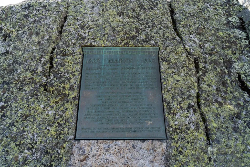
Mount Marcy, which is also known as “Tahawus” by local Native Americans, which means “cloud-splitter,” is located in the High Peaks Wilderness in Adirondack Park in Upstate New York. Sounds confusing? Let us explain!
Adirondack Park was created in 1892 and encompasses 6 million acres and is the largest publicly protected nature area in the contiguous United States. It is the size of the entire neighboring state of Vermont and is larger than Yellowstone, Yosemite, Glacier, Grand Canyon, and the Great Smoky Mountains…combined!
This park is sometimes referred to as the “Blue Line,” which is because when they were originally drawing the maps for the park, the cartographers used blue ink to create the boundaries of the park. You can see Adirondack Park on the map above, the larger of the two blue lined areas (the smaller is Catskills Park).


Inside of the Blue Line are many villages and towns, as well as the High Peaks Wilderness, which is where you can find the 46 High Peaks of the Adirondacks, nicknamed 46ers, and are for the most part over 4,000 feet tall. Many people work to become a ADK 46er, which is someone who has hiked all 46 High Peaks.
Mount Marcy is the highest peak in the High Peaks Wilderness Area of the Adirondack Mountains, as well as in the entire state of New York, at an elevation of 5,344 feet. The views from the top are spectacular and on a clear day, you can see many of the Adirondack High Peaks.
Before embarking on your adventure, please review the Leave No Trace principles to ensure you leave every place better than you found it, so that others can enjoy these beautiful places for many years to come!
These seven principles include planning ahead and preparing, hiking and camping on durable surfaces, disposing of waste properly (pack out what you pack in!), understanding campfire rules and always fully extinguishing your fires, respecting wildlife, and being considerate of other visitors.
How to get to the Adirondacks + Mount Marcy
While there are a bunch of smaller towns in the Adirondacks, overall it is pretty remote and more challenging to get to, with no major cities nearby. However, getting to the Adirondacks and Mount Marcy is well worth the effort. The area is gorgeous and the towns are super charming!
Mount Marcy is technically located in Keene, New York, but Lake Placid is the closest larger town to the trailhead and will be used for the calculations below.

Flying to the Adirondacks
The closest larger airports to Lake Placid are the Burlington International Airport (BTV) and the Albany International Airport (ALB).
BTV is located in Burlington, Vermont, which is between a 2-2.5 hour drive, including a ferry across Lake Champlain. BTV is serviced by American, Delta, Frontier, jetBlue, United, and Sun Country Airlines and has nonstop flights from Atlanta, Charlotte, Chicago, Orlando, Dallas, Denver, New York City, Philadelphia, and Washington DC.
ALB is located in Albany, New York and is about a 2 hour, 15 minute drive to Lake Placid. ALB is serviced by Allegiant, American, Delta, Frontier, jetBlue, Southwest, and United, with nonstop flights from Atlanta, Baltimore, Charlotte, Chicago, Orlando, Dallas, Detroit, Ft. Lauderdale, New York City, Philadelphia, and Washington DC.
Driving to the Adirondacks
If you plan to drive to the Adirondacks, here is how long you can expect to be on the road from nearby destinations:
- Syracuse, NY: 3.5 hours (200 miles)
- New York, NY: 5 hours (296 miles)
- Boston, MA: 5 hours (259 miles)
- Niagara Falls, NY: 6 hours (355 miles)
Getting around the Adirondacks
Since the Adirondacks and Mount Marcy are pretty remote, we highly suggest having a car (or renting a car) to be able to get around easily and get to the Mount Marcy trailhead. There is a shuttle option to one of the trailheads for Mount Marcy, which we will explain below, but having your own car will be easiest.
The Different Routes to Hike Mount Marcy

There are many trails in the High Peaks Wilderness area of Adirondack Park, which you can combine to create a ton of different route options. And the hike to Mount Marcy is no different! There are quite a few ways to do this hike, with day hiking and backpacking options.
Below are some of the most popular route options, but regardless of which route you take, something good to know about hiking in the Adirondacks is that it is HARD. We are pretty used to hiking at high altitude and on tough trails out West, but what really surprised us about hiking out East is how intense the trails are.
While the altitude may not be as high, you gain a lot of elevation with hardly any switchbacks and the terrain is very rocky and rooty, making each step a bit slower so you don’t trip and fall. We definitely underestimated how difficult this area would be to hike in and while we were able to conquer it, it definitely kicked our butts.
Van Hoevenberg Trail
Miles: 16.7
Elevation: 3,540 feet
Reviews & Current Conditions
This is the most popular route to hike Mount Marcy, especially if you plan to do the hike as a day hike. This route will take you the same way up and down Mount Marcy, starting and ending at the Adirondack Loj, going by Marcy Dam, and then up through the forest to the summit.
This hike takes an average of 9 hours, but plan for longer so you can have plenty of breaks and enjoy the summit.
Where to park
For this route you will park at the Adirondak Loj, which is a popular trailhead for many trails in the High Peaks Wilderness. This parking area costs $15 per car per day for non-members of the Adirondack Club, which you may have to self pay with an envelope, so make sure you have cash!
While there is ample parking, with several parking lots that can hold probably 100+ cars total, the lots fill early during peak season (in the summer by 8 AM). We arrived before 6 AM on a weekday in September and there were plenty of spots, but many people were arriving around this time.
So make sure to get there early to ensure you have a spot! If you get there too late there is a small overflow area about a mile down the road on South Meadows Road.
How to backpack this route
If you don’t want to do this as a day hike, you can make this a one night backpacking trip and camp at Marcy Dam, which has many sites to choose from.
This is a good idea if you get a later start, want to add on some side trips to other trails in the area, or if you want to break up the hike into smaller chunks. The perk of backpacking this route is that you can leave your backpacking gear at Marcy Dam and summit without lugging it all up there.
South Meadows to Van Hoevenberg Trail
Miles: 15
Elevation: 3,559 feet
Reviews & Current Conditions
This route is very similar to the one above, but with a different starting point on South Meadows Road. You will begin on the Marcy Dam Truck Trail, which will be pretty flat and probably a bit boring, before connecting with the Van Hoevenberg Trail at Marcy Dam.
People enjoy this route because you do not have to pay to park, like you do at Adirondack Loj, and the beginning part of the trail is a lot less busy than the hike to Marcy Dam along the Van Hoevenberg Trail.
Where to park
You will park at the end of South Meadows Road or along South Meadows Road if the end parking area is full. This is a narrow, dirt road, with campsites scattered throughout, so be mindful that it may be tight for super large vehicles. You can also camp in one of the marked spots the night before to do this hike, to ensure you have parking and start early.
How to backpack this route
Similar to the route above, you can camp at Marcy Dam the night before summiting to make your summit hike a bit shorter. This is also a good way to get an extra early start for the summit and beat some crowds.
Avalanche Lake to Mount Marcy Loop (Our Route)
Miles: 20
Elevation: 3,802 feet
Reviews & Current Conditions
This is the backpacking route we took up to Mount Marcy and we loved it! We chose this route because we wanted to see more than just Mount Marcy and this route includes multiple lakes (Avalanche Lake, Lake Colden, and Lake Tear of the Clouds), as well as some fun features like ladders and catwalks along the side of rock walls (called Hitch-Up Matildas), which we will talk about more in the “our experience” portion.
You can do this route either clockwise or counter clockwise, but we did it counter clockwise, going to Avalanche Lake and Lake Colden first and then summiting Marcy on our second day.
Regardless of which direction you choose, you’ll get to experience the traditional Van Hoevenberg Route, but also get to see different things that many Mount Marcy day hikers miss while on the Avalanche Pass Trail.
Where to park
This route begins at the Adirondack Loj, just like the Van Hoevenberg Trail.
How to backpack this route
We recommend doing this route as a backpacking route, NOT a day hike. It is long and grueling and you’ll want to make sure you have time to enjoy the sights along the way.
We did this in two days, hiking to Lake Colden the first day and camping there and then continuing on to Mount Marcy the next day and going down the Van Hoevenberg Trail. The downside of this is that we had to lug our gear up Mount Marcy, which made the already hard hike about 10x harder. You can see our exact route here.
But you could do this as a three day trip, backpacking to Lake Colden and staying the night, summiting Marcy without your gear the next day and then going back to Lake Colden (8-ish miles round trip), and hiking out the same way you came on day three. This will make the route longer than the 20 miles listed above.
Mount Marcy + Algonquin Peak
Miles: ~17.5 miles
Elevation: 5,686 feet
See Route
This is the route that one of our favorite YouTubers, Kraig Adams, hiked and what inspired us to backpack to Mount Marcy.
This route is similar to the one we backpacked, but instead of hiking to Avalanche Lake, you will get to summit another 46er, at 5,114 feet. The trail starts and ends at the Adirondack Loj and you will follow the Van Hoevenberg Trail to the summit of Mount Marcy before going on the other side of the summit, hiking to Lake Colden, and then meeting up with the Algonquin Trail.
After summiting Algonquin Peak, you will follow the same trail for almost 3 miles where you can either hike the Old Marcy Dam Trail or Van Hoevenberg Trail back to Adirondack Loj. You can do this route the opposite way as well, summiting Algonquin Peak first and then Mount Marcy.
Where to park
You will want to park at the Adirondack Loj for this hike.
How to backpack this route
This is another route that we highly suggest backpacking vs. doing a day hike. You will want at least two days to do this, likely camping at Lake Colden before or after summiting Mount Marcy, depending on which direction you want to go.
Mount Marcy from Johns Brook Lodge
Miles: 16.6
Elevation: 3,979 feet
Reviews & Current Conditions
This route starts from the Garden Trailhead near the town of Keene Valley and is an out and back route, but there is a loop section at the end that does provide some variety.
This is a less popular way to hike Mount Marcy and does require some scrambling with cables to help you, but for what it’s worth, some reviews on AllTrails talk about their 10 and 12 year old kids completing this.
From the Garden Trailhead you will take the Phelps Trail 3.3 miles toward Johns Brook Lodge. At the lodge area there are campsites you can use if you are planning to do this route overnight.
From the lodge you’ll have almost 5 miles to the summit of Mount Marcy. To reach the summit, continue on the Phelps Trail, but on the way down you have the option to take the Hopkins Trail, which will meet back up with the Phelps Trail.
Where to park
For this route, you will park at the Garden Trailhead, which is a popular trailhead serving several hikes in the area. However, this parking lot is not large, so make sure to arrive early, as it can fill by 6 AM in the summer months. Similar to Adirondack Loj, there is a fee to park here, which costs $10 per day, so make sure to bring cash.
However, if you’re concerned about parking, you do have another option. You can ride the Marcy Field to Garden Trailhead Shuttle. The shuttle runs from 7AM to 7PM on the weekends, which may not be enough time to summit Mount Marcy in one day, as the shuttle does have wait times.
For backpackers, you are allowed to park your car overnight at Marcy Field, but keep in mind that if you are planning to get back to your car during the week, you’ll have to have your own transportation back to Marcy Field, which is about 3.5 miles.
You can see some FAQs for the shuttle here, but make sure to check this page for updates on the 2022 schedule.
How to backpack this route
If you’d like to do this as an overnight trip, there are areas to camp near John Brooks Lodge, as well as closer to Mount Marcy. This would be a great option if you want to reduce the daily mileage and since you’ll go back the same way you came (for the most part), you can leave your gear at camp while you hike to the summit.
When to hike Mount Marcy

Mount Marcy can be hiked year round, but your experience will vary. Here is what to expect during each season!
Winter
You can hike Mount Marcy in the winter, but you will need to be prepared, as there very likely will be ice and snow. We highly suggest being comfortable and experienced with winter hiking to attempt this and bringing snowshoes, crampons, many layers, emergency gear, and other winter hiking gear.
The best route option for the winter is one of the routes starting from the Adirondack Loj, which is open during the wintertime. And we do hear that the winter has one advantage: the trails are not as rocky, rooty, and muddy, since they are covered in snow.
Spring
The spring might not be a very fun time to hike to Mount Marcy. Although the temperatures will rise out of the below freezing temperatures, the snow will be melting which means the trails will be extra wet. We hiked in September and there were several spots that were very wet and muddy, so we can only imagine how muddy it would be with all the snow melt.
However, the spring does bring less crowds than the summer, which is a plus.
Summer
With beautiful weather and snow-free trails, the summer is the most popular time to hike to Mount Marcy, which means that the trail gets pretty packed, especially on the weekends. If you plan to hike in the summer, you will need to start very early to avoid some crowds and enjoy the hike.
Fall
In our opinion, the fall is the best time to hike Mount Marcy! If you hike in early fall, you’ll be treated to nice weather, snow-free trails, and fewer people than in the summer. And depending on when you go, you may get to see some gorgeous fall foliage too! The trails can still get busy on the weekends, especially as the leaves change, but when we hiked on a weekday in late September, we didn’t encounter many others, even at the summit.
Time of Day
We cannot stress this enough: start early! We suggest being on the trail right before sunrise (or even earlier if you feel comfortable). When we started around 6 AM in late September, we didn’t encounter too many people on the trail and the trail was easy to follow in darker conditions.
We also highly suggest going on a weekday, regardless of the season, as this will bring less people. The weekdays in the summer are still busy due to summer vacations, but weekends will bring even more people to the area.
Do not hike if it may storm
With the summit being above the treeline and fully exposed, it is a very dangerous place to be if there is a chance of lightning. Weather can change quickly in the mountains, so if it looks unsafe, turn around.
Things to know before hiking Mount Marcy


Before hitting the trail, here are a few things to know about hiking to Mount Marcy to ensure you have a safe, responsible, and fun hike.
Fees & permits
While there are parking fees depending on where you park, there is not a fee or permit required for the actual hike.
Sign in to the register
No matter what trail you take, be sure to sign in to the hiker registry so that there is a record of you entering the park, just in case you get hurt or need help. This also helps the people managing the area know how many people are using the trails so that improvements and changes can be made.
Dog friendly
Mount Marcy is dog friendly, so feel free to bring your best furry friend along with you, but make sure to keep them on a leash, especially in alpine areas. Our pup Kona loved this hike!
Restrooms
There are restrooms at the trailhead, as well as pit toilets near camping areas. If you decide to use the restroom outside of these toilets, please ensure you go at least 100 feet from any water source.
And PLEASE pack out any toilet paper and make sure to use a trowel to dig a hole for human waste. You can also bring a wag bag to carry out your waste, although not required.
Campsites
There are many campsites in the High Peaks Wilderness, which are marked with a yellow marker on the trees, as well as marked on the AllTrails map. Please use these designated sites to prevent further erosion.

Lean-tos
There are about 200 lean-tos that can be found all over Adirondack Park, with 5 at Marcy Dam and another 5 near Lake Colden. They are wooden log shelters with three sides and are normally first-come, first-served.
The size of them can vary, but they typically can accommodate 7-8 campers. The etiquette for lean-tos is if your group is less than the maximum capacity for the lean-to, you should share the space with other parties if no other lean-tos are available.
There are also 3 additional rules created by the New York Department of Environmental Conservation, which you can read more about here, with the most important being you cannot pitch a tent inside the lean-to.
Because you cannot reserve a lean-to, it is a good idea to bring your tent with you just in case there is no room available. And just like anywhere else in nature, please do not leave trash or deface any structure with initials or other markings.
No Fires
Campfires are NOT allowed in this area of the High Peaks Wilderness, so make sure you have a camp stove to make meals.
Watch where you step
When you get above the treeline, please watch where you walk, as there is endangered alpine vegetation that is very fragile. Make sure to not step in areas that are roped off, stick to established trails, leash your dog, and follow the markers on the exposed rock.
Wind
Mount Marcy is known to have some gnarly wind with gusts up to 75 mph regularly, so make sure to pack lots of layers for the top!
Drones are not allowed
This hike is in the Wilderness and drones are NOT allowed in Wilderness areas.
What to bring to hike Mount Marcy

To see everything we recommend packing on your trip, check out our hiking gear and backpacking packing list where we share everything we bring with us on most hiking and backpacking trips, including the 10 essentials. But for this specific hike, we have a few items we really want to stress bringing with you.
PS: if you are looking for any last minute gear, Adirondack Lakes & Trails Outfitters in Saranac Lake offer camping rentals and the High Peaks Information Center by the Adirondack Loj sells some backpacking items, as well as rents bear canisters.
Offline map
We’d highly recommend downloading the AllTrails map before you go. There are many trails in the area and you’ll want to ensure you don’t miss a turn. You will need an AllTrails + membership to download maps, which is $35.99 a year and so worth it!
Want to get 30% off an AllTrails+ membership? Use our code aplusk30 (you must redeem this code on the website, not the app)!
We use AllTrails+ on every single hike and it is the most helpful hiking tool out there! Some of the features we love are offline maps (so we can navigate even without cell service), wrong-turn alerts, and its 3D maps feature, so we can get a feel for trails before we hike.
Bear Canister
More than half of the black bears in New York state call the Adirondack Park home. For this reason, it is required that you carry a bear proof canister between April 1 and November 30 if you are camping overnight. There have been issues in the past with black bears getting into food, specifically at Lake Colden (we did not see any bears for the record).
It is recommended that you take a hard sided bear canister, like the Backpacker’s Cache Bear Proof Container, as the bears in this area specifically are known to be able to get into the clear plastic bear canisters.
You can read more about the rules, regulations, and tips about bear canisters in the High Peaks Wilderness here. And we suggest refreshing your memory on how to stay safe if you encounter a black bear.
DackMap App
The Adirondacks have their own app called DackMap! This looks like a very useful app because you can see recent reviews on trails, as well as for businesses in the area, plus track your progress on specific challenges in the park, like hiking to all the 46ers.
This app can also be helpful in planning your route as it shows you all the trails, lean-tos, campgrounds, peaks, waterfalls, etc. But one of the coolest and most helpful features of this app is the ability to see live parking capacity updates (including the Adirondak Loj and Garden Trailhead lots) and see a heat map that shows you where the crowds are in the park.
Cash
As we mentioned earlier, some parking lots have a fee, so you’ll want to make sure you have cash on you.
Our Experience hiking Mount Marcy
Now that we’ve shared a bunch of logistics for hiking Mount Marcy, both as a day trip or overnight backpacking trip, we’re going to share a bit about our experience on the trail.
We will be focusing on our route, which was the Avalanche Lake to Mount Marcy Loop, but will break it down by section in case you hike a different route that overlaps with part of this.

Adirondack Loj to Marcy Dam
The trailhead to Mount Marcy begins right at the Adirondack Loj parking lot and after signing into the log book, we hit the first part of the trail to Marcy Dam.
This portion of the trail is rather uneventful, as you’ll just be slowly climbing up through the forest to Marcy Dam. We did most of this part of the hike in the dark, although it was getting lighter, which worked out well since there weren’t many views to see.
Once arriving at Marcy Dam, we got our first glimpses of the High Peaks in the area, which looked gorgeous with the early morning light hitting them. The dam was originally built in the 1930s by the CCC, before being rebuilt in the 1970s. While the dam has since been removed, you can still walk out a little bit where the dam originally was to see some of the views.


Marcy Dam to Avalanche Lake
We crossed a bridge over Marcy Brook to get to the other side of the trail and continued on our hike. Shortly after this is a junction where you can go straight to hike up Mount Marcy via the Van Hoevenberg Trail or go to the right to go onto the Avalanche Pass Trail.


We had decided to do Avalanche Pass first, so we signed into another log book and continued onto the new trail. This part of the hike is pretty forested, but there were a couple beautiful features along the way, including a bridge to cross a stream, as well as a cool area where you walk among some tall rock walls.At around 4.8 miles total, we reached Avalanche Lake. The lake is tucked between towering peaks and while it doesn’t have a huge shoreline (it was pretty muddy when we visited), the views are incredible.

But what makes this lake extra exciting are the fun challenges to get from one end to the other! The trail from the north end of the lake to the south end is filled with ladders and these wooden “cat walks” bolted into the rockface, which are called Hitch-Up Matildas. This part of the trail was super fun for us humans, but our pup Kona struggled a bit.


We had heard it wasn’t the most dog friendly area and while she did a few ladders by herself, she started to get nervous and we had to carry her a lot, which wasn’t too bad, except for a few areas where there was a ladder up and then immediately back down, which proved to be a bit tricky with packs on. We made it work and it was worth it, but something to keep in mind if you’d like to bring your dog.

Avalanche Lake to Lake Colden
Once on the other side of the lake we crossed a bridge and continued on to Lake Colden. This part of the trail was once again in the forest, until we started to reach the side of Lake Colden where the views opened up a bit of both the lake and Mount Colden behind it.

There is one final obstacle before getting to the camping area for Lake Colden…another ladder. This one was pretty long and ends at a bridge that you’ll cross at the base of the lake. We helped Kona get down this one and then headed to the camping area to find a spot for the night.

We got to the camping area around 10 AM or so and we were the only ones around, to our knowledge, which meant we had our pick of sites. We wanted to be close to the main trail, so we picked a spot not too far off the trail, which is named Lake Colden 2 on the AllTrails map.

This spot was a short walk to the river, where we made meals and filled up water, before spending the rest of the day mostly just hanging out in our tent. More people arrived throughout the day and another campsite got occupied, but we don’t believe it was ever 100% full.


Lake Colden to Mount Marcy
After a good night’s sleep, we hit the trail early to hike to the top of Mount Marcy. We had about 13 miles until we were back to the parking lot, so we wanted to make sure we had plenty of time.

Almost immediately after starting the trail, we reached a very unexpected feature: a suspension bridge! We love suspension bridges and this one was really narrow, making it extra exciting to cross.


The hike was very forested for the majority of the morning, but along the way we were treated to waterfalls, another ladder to climb, as well as this one area where there was a narrow gorge, with the river running through it. All of these features made the otherwise similar looking scenery a bit more exciting, as we were definitely pretty exhausted from the hike…and we hadn’t even summited yet.


One big downside to this part of this trail though was the mud. It was SO muddy on the trail, which we hear is very common and we found ourselves having to walk super slowly to ensure we didn’t wipe out or fall into a huge mud hole (which did happen once).
After about 3.5 miles of the muddy forest, we reached Lake Tear of the Clouds, which is where we got our first glimpse of Mount Marcy. With only a mile left until the summit, we were shocked by how far away and how high up it looked. It was pretty daunting!


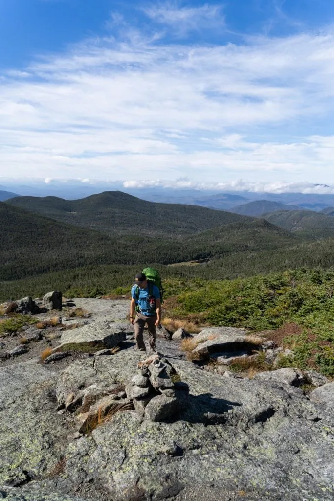
But on the plus side, this is when the trail starts to get really good in terms of views. While most of the hike so far had been in the forest, with a few beautiful lakes, after leaving Lake Tear of the Clouds you start to reach the exposed alpine zone, where you have views all around you!


And WOW, are the views AMAZING! We still had a climb ahead of us, but getting to see the surrounding peaks of the Adirondacks definitely recharged us a bit and gave us the energy to keep pushing.

We met two women about halfway up, who told us that the top was insanely windy, but that the views were even better than what we were seeing at this point, which only got us more excited. We put on our jackets in preparation for the wind and made the final push to the summit.

And they were right! It was CRAZY windy up there, probably the most powerful wind we have ever felt in our lives, almost pushing us over at times, but the 360 degree views were out of this world.


We could see mountains for many, many miles and even saw Lake Champlain and Vermont. Since fall was approaching, there were some patches of orange trees down below, which only added to the beauty.


It was unfortunately way too windy to stay up there for long, so we headed a tiny bit down the path to an area more protected from the wind to eat a celebratory Snickers and take our packs off for a tiny bit.


Mount Marcy to Adirondak Loj via the Van Hoevenberg Trail
After enjoying our little break and celebrating our accomplishment hiking to the top of New York, we began the 8 mile trek back down to the Adirondack Loj. Similar to on the way up, you get to be in the alpine zone for a bit, but this time, on the other side of the peak, which meant we got to enjoy the epic mountain views for even longer.


After about half a mile or so, we went back into the forest, which is where we stayed until we reached the end. To be honest, we were pretty wiped out on the hike from the summit back down to the Adirondack Loj and didn’t really take any photos. We were trying to hike as fast as our tired bodies would let us so we could sit and enjoy a hot meal.
But this part of the trail was pretty straightforward, with nothing crazy to report and once hitting Marcy Dam, we got to repeat the first part of the hike that we had done mostly in the dark, so it was nice to see it in the daylight this time.
After about 19.3 total miles of hiking, we made it back to the parking lot, which was such a glorious sight! While this hike really wiped us out, we loved every second of it (well, minus the mud). The route we did, while mostly forested, still had a good variety of scenery, from lakes, to ladders and Hitch-Up Matildas, a suspension bridge, waterfalls, and alpine territory views. It was worth every second of pain and exhaustion and we hope to climb more of the 46ers in the future!
Where to eat after hiking Mount Marcy

One cool thing about this hike, especially starting at the Adirondack Loj is that they have a spot right at the trailhead called the Hungry Hiker, which serves burgers and a few other items. They were closed the day we visited, but this would be a good, convenient option.
The Hungry Hiker being closed worked out okay for us, since we have a tradition to eat pizza after summiting the highest point in a state. We headed to Big Slide Brewery & Public House in Lake Placid for some well deserved pizzas. They have really unique flavors here (which do change often) and we both really enjoyed it!
Some other restaurants nearby to check out are: Lisa G’s, Smoke Signals, and Eleanor’s Pasta Kitchen.
Where to stay before or after hiking Mount Marcy
There are a handful of places to stay before or after hiking Mount Marcy, including a variety of lodging options near Lake Placid, a lodge right at the trailhead, and even a free option nearby!

Adirondak Loj
We’ve mentioned Adirondack Loj (pronounced “lodge”) a few times in this guide, as it’s one of the main starting points for this hike, but besides being the launching point for this hike, there are also a handful of lodging options, making it the most convenient place to stay before or after hiking Mount Marcy.
Loj
The Adirondak Loj was built in 1927 and accommodates up to 38 guests in a combo of private rooms, bunk rooms, and a co-ed loft. There is a main living room with a large fireplace where you can hang out with your buddies after a long adventure and read a book from their library.
The Loj offers cooked warm meals in the rustic dining room for those staying in the Loj. Breakfast is included in the price, with options for lunches and dinners.
Cabins
Also at the Loj are 3 cabins, which accommodate either 4, 6, or 16 people and have a kitchen and a bathroom. Meals can be purchased at the Loj for an additional fee.
Campsites
There is also a campground with 31 tent sites, 16 lean-tos, 6 canvas cabins, and 1 yurt (winter only, with heat and electricity).
Hotels
Lake Placid has a variety of hotel options and here are a few that we would suggest:
- Hampton Inn & Suites Lake Placid
- Lake Placid Inn: Residences: These offer a more apartment-like experience, with a full kitchen!
- Town House Lodge: this is a chic motel in downtown Lake Placid and each room has a kitchenette with access to a large, shared kitchen and lounge.

Airbnbs
If you want a more homey experience before or after your hike, these Airbnbs in Lake Placid will be a nice, comfortable place to stay before potentially sleeping in a tent. Warning: Airbnbs in Lake Placid are not the cheapest!
Modern Mountain Private Apartment (1 bedroom, 1 bathroom): This apartment has a simplistic, modern design and is right by town!
Eclectic Apartment (1 bedroom, 1 bathroom): This apartment has some colorful retro features, plus a patio with a grill!
Amazing apartment walking distance to everything! (1 bedroom, 1 bathroom): This apartment has everything you’ll need for a nice stay in Lake Placid. It is newly remodeled, walking distance to Main Street, and is affordable for the location and quality.
GO Cottage (1 bedroom, 1 bathroom): The GO Cottage is a studio style cottage built in 1920 and has been featured in a few magazines and TV shows. It has a fully fenced and private outdoor space and dogs are welcome.
Radiant apartment in the heart of Lake Placid (2 bedrooms, 2 bathrooms): This apartment is right in the heart of Lake Placid and looks very nice! It has all the amenities you’ll need like a kitchen ready to cook, beautiful design, and washer and dryer.
CAZA Loj (3 bedrooms, 2.5 bathrooms): This place looks too cool! It has 100 year old barnwood on the inside walls coupled with a modern design. There is lots of natural light flooding in, in floor radiant heat, and a wood burning stove. Along with the beautiful interior, there is an outdoor space with a fire pit.
Campgrounds
Privately Owned Campgrounds
Lake Placid / Whiteface Mountain KOA Holiday
We stayed here for one night after hiking Mount Marcy since we were low on power and needed hot showers. It was a typical KOA campground with nice, clean facilities, but it definitely isn’t cheap.
Draper’s Acres
This campground offers cabins, tent sites, RV sites, dump stations, and shower houses. It is more of a bare bones campground vs. a KOA-like camping resort and they describe themselves as ”simply a home base for those who choose to embrace the nature surrounding us.”
New York DEC Campgrounds
There are several state run campgrounds within an hour of the Adirondak Loj. All tent sites are $18 per night and can be reserved through Reserve America.
Meadowbrook Campground (20 minute drive)
Wilmington Notch Campground (25 minute drive)
Lincoln Pond (45 minute drive)
Sharp Bridge Campground (45 minute drive)
Boondocking
We spent a few nights while in the area camping at one of the FREE dispersed campsites along South Meadows Road. There are quite a few campsites (you can only camp in designated sites), but we will say the road and the campsites are a bit tight and would not be good for full sized RVs. For our Sprinter van it was totally fine! Also, do not expect cell service here, so make sure you have maps downloaded beforehand.
We hope that this guide gives you a better idea of what to expect when hiking Mount Marcy, whether you do the same route as us, a different backpacking trip, or just a day hike. You can watch our full experience here!
Ready to hike Mount Marcy?
Pin this Mount Marcy hiking guide to help plan your adventure!


Very informative. Thank you from Ontario.
We are so glad you found it helpful!
This is very helpful information my husband and i plan on hiking Mt Marcy some time in 2024.
We’re so glad!